Where is Kilimanjaro Located? A Deep Dive into Africa’s Rooftop
Introduction: More Than Just a Point on a Map
Ask most people where Mount Kilimanjaro is, and they will vaguely point to “Africa.” While technically correct, this answer barely scratches the surface of one of the world’s most fascinating geographical features. Kilimanjaro is not just a mountain; it is a dormant stratovolcano, an ecological time capsule, and a geological anomaly. Its location is the very reason for its existence, its unique climate, and its legendary status as the highest free-standing mountain in the world. This article will go far beyond a simple coordinate check, exploring the tectonic, political, climatic, and cultural coordinates that define the "Roof of Africa."
Part 1: The Precise Geographic Coordinates
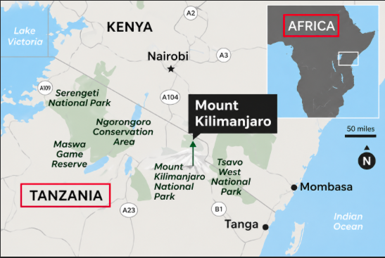
At its most fundamental, Mount Kilimanjaro is located in northeastern Tanzania, a country in East Africa. Its summit, Uhuru Peak on the crater rim of Kibo volcano, sits at 3°4'33" South latitude and 37°21'12" East longitude.
To visualize this:
Latitude (3°S): This places it just 205 miles (330 km) south of the equator. This equatorial proximity is critical—it means the mountain experiences very little seasonal temperature variation, yet its summit is permanently covered in ice and snow. This paradox is the mountain’s most famous characteristic.
Longitude (37°E): This aligns it with the eastern branch of the Great Rift Valley, a massive geological fault line that has shaped the landscape of East Africa for millions of years.
If you were looking at a satellite image, Kilimanjaro appears as a stark, blue-white dot on a sea of ochre and green savannah. It is not part of a mountain range like the Rockies or the Alps. Instead, it stands entirely alone, rising abruptly from the flat plains of the Masai Steppe. This isolation is why it looks so impossibly large; from the surrounding plains, its summit seems to float in the sky, unencumbered by neighboring peaks.
Part 2: Political and Administrative Location
While the mountain is easily visible from southern Kenya, its summit and the vast majority of its slopes lie entirely within the borders of the United Republic of Tanzania.
Country: Tanzania
Region: Kilimanjaro Region (Mkoa wa Kilimanjaro)
Districts: The mountain straddles three main districts: Rombo, Hai, and Moshi Rural.
Nearest City: Moshi (population ~200,000). Located at the southern base of the mountain, Moshi is the primary gateway for climbers. It is a bustling market town known for its coffee plantations and as the headquarters for Kilimanjaro National Park.
Nearest Major Airport: Kilimanjaro International Airport (JRO), situated between Moshi and Arusha, approximately 30-40 minutes' drive from the mountain’s base.
The Kenyan Border Confusion
A common misconception is that Kilimanjaro is in Kenya. This myth persists because the mountain looks spectacular from Amboseli National Park in Kenya, and because early European explorers often approached from the Kenyan side. However, the international border runs along the northern base of the mountain, roughly at the 2,500-meter (8,200-foot) contour line. Kenya owns the lower northern slopes, but Tanzania owns the summit. Attempting to climb from Kenya is impossible without illegally crossing the border.
Part 3: Geological Location – The Rift Valley and the Volcanoes
To truly understand why Kilimanjaro is where it is, we must look 100 kilometers (62 miles) beneath the Earth’s surface. The mountain sits on the East African Rift System, a divergent tectonic plate boundary where the African plate is slowly splitting into two: the Nubian plate (mainland Africa) and the Somali plate (Horn of Africa).
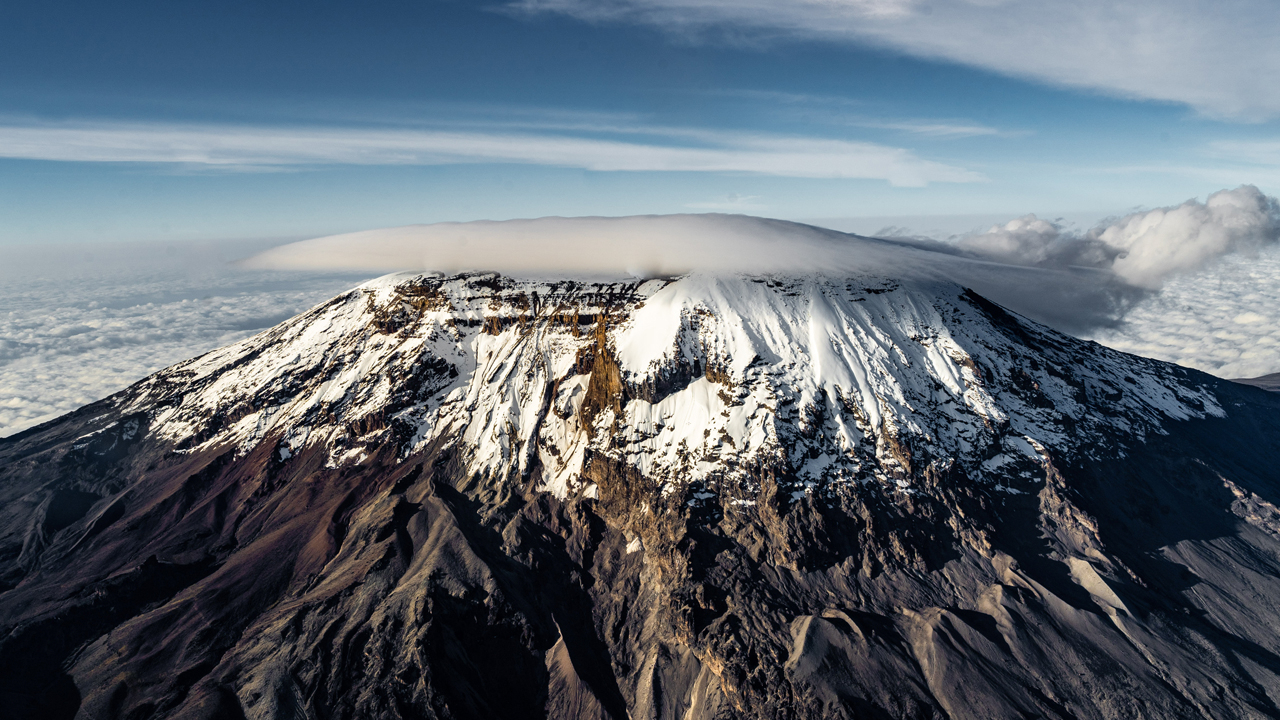
Around 750,000 years ago, immense volcanic activity exploited a weak spot in the Earth’s crust. Kilimanjaro is not a single volcano but three distinct volcanic cones:
Shira (west): The oldest, extinct, now a collapsed caldera forming a high-altitude plateau.
Mawenzi (east): The second oldest, extinct, highly eroded with jagged, spire-like peaks. Climbers rarely summit Mawenzi due to its technical difficulty.
Kibo (central): The youngest, dormant (not extinct), and the highest. Uhuru Peak is on Kibo’s crater rim.
This location on the Rift means the mountain is technically still alive. While Mawenzi and Shira are dead, Kibo last erupted approximately 150-200 years ago. Fumaroles (steam vents) inside Kibo’s crater still emit hot gases, confirming the presence of magma just 400 meters (1,300 feet) below the summit’s crater floor.
Free-Standing Giant
Because it is a product of a single rift volcano rather than an orogenic belt (mountain range formed by colliding continents), Kilimanjaro is free-standing. It rises 4,877 meters (16,000 feet) from its base to its summit, making it the tallest free-standing mountain on Earth. By comparison, Mount Everest’s base is already on the Tibetan Plateau, so its “prominence” (rise from surrounding terrain) is less than that of Kilimanjaro.
Part 4: Climatic Location – From Equator to Arctic in 4 Hours
Kilimanjaro’s location straddling the equator and its extreme vertical rise create a remarkable series of ecological zones. The mountain is so tall that it creates its own weather.
Zone 1: Cultivated Zone (800m – 1,800m / 2,600ft – 5,900ft)
Location: The base.
Climate: Warm and humid (25-30°C / 77-86°F).
Detail: This is the coffee and banana belt. The volcanic soil is incredibly fertile. The town of Moshi sits here, and the constant moisture from the mountain’s rain shadow feeds the region.
Zone 2: Rainforest (1,800m – 3,000m / 5,900ft – 9,800ft)
Location: The lower slopes.
Climate: Wet and misty. Receives 2,000mm (80 inches) of rain annually.
Detail: This zone is a critical water catchment area. Rivers like the Pangani originate here. The air is thick with mosses, ferns, and towering hardwoods. Colobus monkeys and turacos live here.
Zone 3: Heath and Moorland (3,000m – 4,000m / 9,800ft – 13,100ft)
Location: The mid-slopes.
Climate: Cooler, diurnal temperature swings (hot days, freezing nights).
Detail: Vegetation becomes alien-like: giant lobelias and giant groundsels (Dendrosenecio kilimanjari) that are endemic to this specific location. These plants have adapted to freeze at night by producing a natural antifreeze goo.
Zone 4: Alpine Desert (4,000m – 5,000m / 13,100ft – 16,400ft)
Location: The saddle between Mawenzi and Kibo.
Climate: Extreme. Solar radiation during the day is fierce (UV index > 11), but night temperatures drop to -10°C (14°F). Humidity is near zero.
Detail: This is a rocky, scree-covered wasteland. Nothing grows except lichen. The location here is so harsh that climbers experience both sunburn and frostbite in the same day.
Zone 5: Arctic Summit (Above 5,000m / 16,400ft)
Location: Kibo’s crater and Uhuru Peak.
Climate: Permanent winter. Night temperatures can hit -20°C (-4°F) or lower.
Detail: Despite being on the equator, the summit is covered by glaciers and ice fields. The most famous is the Furtwängler Glacier. However, due to climate change, these glaciers have shrunk by over 80% since 1912. Scientists predict that the location’s iconic white cap will be gone by 2040-2050.
Part 5: Human and Cultural Location
The mountain is not just a physical landmark; it is a spiritual and economic center.
The Chagga People: The slopes of Kilimanjaro are the traditional home of the Chagga (Wachaga) people. They have lived on the mountain’s fertile southern and eastern slopes for over 400 years. They developed sophisticated irrigation systems (mfongo) that channel glacial meltwater into terraced banana and coffee farms. For the Chagga, Kilimanjaro is Kipoo (the mountain of whiteness), a sacred place where their god Ruwa resides.
The Maasai: On the northern and western slopes, the nomadic Maasai pastoralists view the mountain as a sign of divine favor. They call it Ol Doinyo Oibor ("The White Mountain") or Ol Donyo Lengai (though that name technically belongs to a different volcano in Tanzania). For the Maasai, the location of Kilimanjaro marks the boundary between wet, fertile lands and the arid savannah.
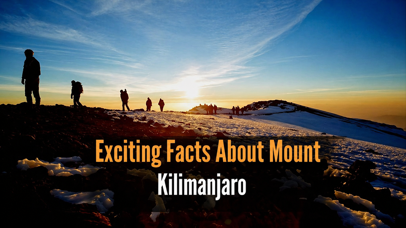
Economic Location: Kilimanjaro’s location is the economic engine of northern Tanzania. The Kilimanjaro National Park, established in 1973, generates millions in revenue. Approximately 35,000 to 50,000 climbers attempt the summit annually, each paying entry fees (around $100-200 USD per day), guide fees, and porter fees. This supports a massive local workforce of porters, cooks, guides, and drivers.
Part 6: How to Get There – Reaching the Location
Understanding the location is academic until you know how to arrive.
By Air: International travelers fly into Kilimanjaro International Airport (JRO) . Located at 2°45'43"S, 37°30'22"E, it sits between Mount Kilimanjaro and Mount Meru. From JRO, it is a 45-minute drive to the town of Moshi.
By Road: From Arusha (the safari capital), it’s a 2-hour drive (130km / 80 miles) east on the A23 highway. The mountain is visible for the entire journey, growing larger with every kilometer.
The Gateways: There are six official approach routes to the summit, each originating from a different location around the mountain’s base:
Marangu Route (South): Starts at Marangu Gate (1,860m). The oldest, most established route.
Machame Route (South-West): Starts at Machame Gate (1,640m). The most scenic.
Lemosho Route (West): Starts at Londorossi Gate (2,360m). The longest and best for acclimatization.
Shira Route (West): Starts via the Shira Plateau. Often merged with Lemosho.
Rongai Route (North – Kenyan side): Starts near the Kenyan border (1,950m). The only route that approaches from the north, offering drier conditions.
Umbwe Route (South): Starts at Umbwe Gate (1,800m). The steepest and most direct.
Conclusion: A Location Under Threat
So, where is Kilimanjaro? It is a precise dot on the map: 3°4'33"S, 37°21'12"E, in Tanzania. But that coordinate belies a dynamic, living entity. It is a mountain whose location defines a nation’s identity, supports 1 million people with fresh water, and hosts five ecological zones in a single vertical climb.
However, the location is changing. The glaciers are melting. The rainforest is receding due to fire and agriculture. By 2050, the question “Where is Kilimanjaro’s snow?” may be answered with “Only in photographs.” To stand on Uhuru Peak is to stand at the intersection of tectonic violence, human history, and climate reality. It is, without hyperbole, one of the most significant geographic locations on Earth—a free-standing giant that will never be repeated.
Final detail: For reference, the summit of Kilimanjaro (5,895m / 19,341ft) is higher than any peak in Europe, North America (excluding Alaska), South America (excluding the Andes), or Australia. Only the Himalayas and the Andes have taller mountains, but none are free-standing like this one.